-
We’re currently investigating an issue related to the forum theme and styling that is impacting page layout and visual formatting. The problem has been identified, and we are actively working on a resolution. There is no impact to user data or functionality, this is strictly a front-end display issue. We’ll post an update once the fix has been deployed. Thanks for your patience while we get this sorted.
You are using an out of date browser. It may not display this or other websites correctly.
You should upgrade or use an alternative browser.
You should upgrade or use an alternative browser.
Is the CAMC UK Route Planner fine to use?
Page 2 - Passionate about caravans & motorhome? Join our community to share that passion with a global audience!
Managed to successfully drive down to England.
We travelled down the road from Whitby to Pickering then West Ayton
We travelled down the road from Whitby to Pickering then West Ayton
I've just put in a route that 95% of satnavs for other than cars get wrong.
No surprise it gets it wrong and directs down a very small road with a 6'6" width limit.
Anyone want to try it, it's to Gear Farm near Helford coming from somewhere not on the lizard. If it takes you round Mawgan creek and up Gear Hill it's wrong. It has to be approached in he opposite direction from St Martin
Don’t know why Sat Nav’s ask for your dimensions when it clearly doesn’t take them into consideration..
The satNavs when you put in 2 metre wide, will take you down a road 2 meter wide.Don’t know why Sat Nav’s ask for your dimensions when it clearly doesn’t take them into consideration..
My Snooper truck and Caravan SatNav, I set it to 3 metres wide, so no narrow roads, might be a longer route but check on Google maps.
Ignore Google. We just drove from Barnstaple in Devon to New Milton in Hampshire using Google. It was a right laugh.
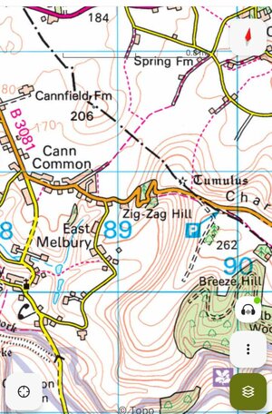
Went along this road & did Zig Zag Hill, then further on met a tractor & trailer with about 8 tons of bales on the back & had to reverse…
Ive absolutely no idea why I didn’t just plan my own route using OS maps which I have on my phone.
I’m a dafty.
Went along this road & did Zig Zag Hill, then further on met a tractor & trailer with about 8 tons of bales on the back & had to reverse…
Ive absolutely no idea why I didn’t just plan my own route using OS maps which I have on my phone.
I’m a dafty.
Attachments
I don't think you can justify blaming Google for encountering a tractor! When you use Google and indeed most routing systems, you can select certain options such as avoiding toll's, motorways, and ferries, but also more generic issues such as fastest, shortest etc.Ignore Google. We just drove from Barnstaple in Devon to New Milton in Hampshire using Google. It was a right laugh.
Went along this road & did Zig Zag Hill, then further on met a tractor & trailer with about 8 tons of bales on the back & had to reverse…
Ive absolutely no idea why I didn’t just plan my own route using OS maps which I have on my phone.
I’m a dafty.
I suggest you check your options.
I used to programme my Garmin via my PC for the required route, ensuring that near the site I used the sites own directions. These days it’s even easier with Streetview and Google earth. But we always carried a map book in the car, and rarely if ever did I follow a satnav diversion whether it be car,Garmin or Google. To most satnav devices a 2 metre country lane at national speed limit is treated no differently to a A road at national speed limit. So if you have shortest or fastest set it will route you whichever meets the settings. It’s only a dumb calculator when alls said and done.I don't think you can justify blaming Google for encountering a tractor! When you use Google and indeed most routing systems, you can select certain options such as avoiding toll's, motorways, and ferries, but also more generic issues such as fastest, shortest etc.
I suggest you check your options.
Can’t believe at 17 myself and with my then to be wife I drove my Dad’s car to Interlaken with only maps and route cards to navigate by 😱
Last edited:
On our European trips, as well as those at home. Pre, any decent satnav, I spent hours on route planning using AA and Via Michelin., as well as local site instructions. A typical trip would be about 20 pages long identifying every stop. I would print two copies, one for our friends. And it worked very well nearly all of the time.
Prior to that, we would order our routes from the AA. Which was a good service at that time.
John
Prior to that, we would order our routes from the AA. Which was a good service at that time.
John
Heavens, mention of the AA route planning service takes me back too many years.On our European trips, as well as those at home. Pre, any decent satnav, I spent hours on route planning using AA and Via Michelin., as well as local site instructions. A typical trip would be about 20 pages long identifying every stop. I would print two copies, one for our friends. And it worked very well nearly all of the time.
Prior to that, we would order our routes from the AA. Which was a good service at that time.
John
The main problem with the pre satnav approach was if my Co pilot fell asleep and lost track of which of the 20 pages we were on 😂
I can't speak of European trips as I've never toured abroad - but for UK touring I used to find 1/4 inch OS maps ideal in the olden days - easy to see the main routes but also possible to pick out short cuts - more recently I use an atlas at 3 miles/inch which stays in the car as backup to satnav failure.On our European trips, as well as those at home. Pre, any decent satnav, I spent hours on route planning using AA and Via Michelin., as well as local site instructions. A typical trip would be about 20 pages long identifying every stop. I would print two copies, one for our friends. And it worked very well nearly all of the time.
Prior to that, we would order our routes from the AA. Which was a good service at that time.
John
I remember planning my route from Shrewsbury to Peterhead for an interview in 1971 - essentially stick to main roads and fork right at Glasgow - but compounded by the M73 still being built and the resulting roadworks on local roads causing some issues.
Did you get the job?I can't speak of European trips as I've never toured abroad - but for UK touring I used to find 1/4 inch OS maps ideal in the olden days - easy to see the main routes but also possible to pick out short cuts - more recently I use an atlas at 3 miles/inch which stays in the car as backup to satnav failure.
I remember planning my route from Shrewsbury to Peterhead for an interview in 1971 - essentially stick to main roads and fork right at Glasgow - but compounded by the M73 still being built and the resulting roadworks on local roads causing some issues.
Yes! Took a while to come to terms with the Doric dialect but look back fondly on my time there - probably shouldn't have left when I did but that's the benefit of hindsightDid you get the job?
When we went to Australia in 2006, I took a Personal Organiser, with a bootleg nav system on it. It took us around Melbourne and Adelaide fine, and the routes in between, The Great Ocean Road, was not possible to go wrong. But, we were running late, so decided to take a short cut inland. I pulled over to start the SatNav just to make sure we were on the right road.
(I remember a friend of mine took a wrong turning and went 5 hours before he realised and the only way back was the way he had gone, plus floods).
We were on the right road. But the SatNav simply said. ‘In 102 miles, vier left’. After that 101 miles it changed to a similar instruction. And that was a short cut!
John
I did a return trip Leicester to Buckie on my 350cc Matchless. Not easy to look at maps/cards, especially at night or in dire weather. But I made it nevertheless.I can't speak of European trips as I've never toured abroad - but for UK touring I used to find 1/4 inch OS maps ideal in the olden days - easy to see the main routes but also possible to pick out short cuts - more recently I use an atlas at 3 miles/inch which stays in the car as backup to satnav failure.
I remember planning my route from Shrewsbury to Peterhead for an interview in 1971 - essentially stick to main roads and fork right at Glasgow - but compounded by the M73 still being built and the resulting roadworks on local roads causing some issues.
I’m blaming myself for not checking on OS 50.000 or 25.000 maps 1st & comparing the route.I don't think you can justify blaming Google for encountering a tractor! When you use Google and indeed most routing systems, you can select certain options such as avoiding toll's, motorways, and ferries, but also more generic issues such as fastest, shortest etc.
I suggest you check your options.
Ive used them for years planning & following mountain bike routes & as you’ll know, show contours & gradients steeper than 14 & 20%. (& hairpin bends)!
In retrospect I should’ve just used the old fashioned Mapnav (AA 250.000) because after I checked there was a much better route avoiding unnamed (yellow) roads.
Does Google maps have the option to avoid certain inclines or roads with a certain width?
Not as far as I know.I’m blaming myself for not checking on OS 50.000 or 25.000 maps 1st & comparing the route.
Ive used them for years planning & following mountain bike routes & as you’ll know, show contours & gradients steeper than 14 & 20%. (& hairpin bends)!
In retrospect I should’ve just used the old fashioned Mapnav (AA 250.000) because after I checked there was a much better route avoiding unnamed (yellow) roads.
Does Google maps have the option to avoid certain inclines or roads with a certain width?
Ive just had a proper look & as far as I can see only have options to avoid motorways, tolls & ferries with the only other option being to input which fuel your using.Not as far as I know.
I asked my son what his FIL uses & he's got a TomTom Camper but he’s not impressed as it’s also taken him down down very dodgy roads & even has said there’s no routes available.
Does your outfit have an issue with inclines? With modern cars this isn't generally an issue as long as you avoid the obvious hills like Chimney Bank in Yorkshire and the Bealach-na-Ba in Scotland.I’m blaming myself for not checking on OS 50.000 or 25.000 maps 1st & comparing the route.
Ive used them for years planning & following mountain bike routes & as you’ll know, show contours & gradients steeper than 14 & 20%. (& hairpin bends)!
In retrospect I should’ve just used the old fashioned Mapnav (AA 250.000) because after I checked there was a much better route avoiding unnamed (yellow) roads.
Does Google maps have the option to avoid certain inclines or roads with a certain width?
It wasn’t the incline I was worried about, not when I was towing with a Jag F Pace 240bhp. It was the tightness of the hairpins with a 7.49mtr Swift Elegance on the back & what might come the other way.Does your outfit have an issue with inclines? With modern cars this isn't generally an issue as long as you avoid the obvious hills like Chimney Bank in Yorkshire and the Bealach-na-Ba in Scotland.
Sutton Bank near us prohibits caravans but Zig Zag Hill is far worse.
(I’ve pedalled up Chimney Bank & driven the Bealach)
Most sat nav instructions I have seen do include a warning, to the effect that the routes the systems selects should only be considered as suggestions, the driver is still responsible for controlling the vehicle and choosing the route to use. Also the driver should use the information on local road signs to avoid unsuitable roads or hazards.
As I initially said, totally my fault for not checking with a reliable mapping system 1st. I was simply saying, ‘ignore Google’.Most sat nav instructions I have seen do include a warning, to the effect that the routes the systems selects should only be considered as suggestions, the driver is still responsible for controlling the vehicle and choosing the route to use. Also the driver should use the information on local road signs to avoid unsuitable roads or hazards.
No need to rub it in Prof. I already admitted to being a dafty on this occasion.
Ordnance Survey from now on if I’m not sure of a route.
Street View’s handy & Ive used that a few times but takes a while if you’re checking a long stretch of road.I simply used Google earth to check the route if it deviated off a main road.
TRENDING THREADS
-
-
-
 Just noticed we have a small crack in the middle of window on awning side from the top (at rear)
- Started by Beachball
- Replies: 9
-
 Mandatory eye tests for drivers over 70 being proposed by HMG. Good or bad?
- Started by Dustydog
- Replies: 230
-
-
Vision Plus Long Mast Pole - Swift Challenger 580 (2017)
- Started by Weebo
- Replies: 2
-